 Discoverijssel is a mobile learn more app that allows users to discover the natural landscape of Overijssel. It was designed in 2008 during the Interface & Interaction Design course – part of the Human Media Interaction programme at the University of Twente.
Objectives
The client for the project was Landschap Overijssel, the Dutch non-profit organisation responsible for maintaining and promoting the natural landscape of the province of Overijssel. In line with their mission, they sought to increase awareness of the region and attract a new audience by proving a mobile experience, which they defined as:
“A mobile, networked system that allows people to share stories, experiences, observations and questions of the landscape around them with others, while they are moving through the environment.”
The project spanned a single iteration, consisting of six months of part-time design, which included task analysis, requirements gathering, interface design and evaluation.
The full details of this process and its results can be found in the final report.
Exploration of User Requirements & Task Analysis
 The first phase of the project sought to understand what constitutes a “visitor” to the landscape of Overijssel, why they go there and what they do. Four fictional persona were constructed to represent initial target users, their different age groups, motivations and abilities and help understand the effects of each on essential use cases.


After having identified potential user needs in the period before, during and after trips to Overijssel, a series of interviews was conducted to better understand the real needs of target users. Special care was taken to conduct the interviews within context, while participants were conducting the sorts of activities the system might support. These interviews provided insight into if and how people planned their trips, how they obtained information and what their attitudes were towards technology (and using technology while out in nature).
Conceptual Design
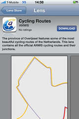
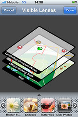
Armed with a better understanding of what users need, Discoverijssel was designed as a free service consisting of a web platform and a mobile client application where users can consume the relevant information that Landschap Overijssel already has about different areas and landmarks. Additionally, both the user and third parties can add information to the system. From the interviews, it was clear that not everybody was likely to share their own content, but people were active in a range of on-line communities. Allowing external content to be contributed through an API allows users to personalise their experience by subscribing to the channels they want. During this phase, the functionality of the system was agreed on, as well as the types of content (trails/routes, photos, recordings etc.).


Interface & Interaction Design
The interface and interaction design phase was limited to the mobile app. After a session of grouping different functionality into screens, the screens were designed in several iterations and refined after a heuristic evaluation session.


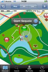
More screens can be found in this set on Flickr.

Evaluation
The first version of Discoverijssel was evaluated in two ways. The conceptual design was evaluated using a video prototype (seen at the beginning of this page) and the interface itself was evaluated using a high-level paper prototype. It was received well and participants were mostly able to complete the tasks that were given.


The client, Landschap Overijssel, was very happy with the outcome. Discoverijssel was awarded with the “best design” award.
For more details, see the final report.